GNSS Explained: The Global System Powering Positioning, Navigation and Time

“You will reach your destination in 7 minutes.”

”In 400 metres, take a right”
That’s all we usually associate navigation services with; a blue arrow following the route to our home on our phone’s Maps app. But what sits behind that interface is not just an app. It is a planetary-scale architecture built over decades.
But the same system is also quietly at work when you tap “Pay” on a UPI app, approve a card payment at a store, or execute trades on a stock exchange; all of which rely on precisely timestamped transactions.
Every time a financial transaction is timestamped.
Every time an aircraft aligns for landing.
Every time a power grid synchronizes across cities.
Even when your pizza arrives at your doorstep.
It is only possible thanks to the satellites in Earth’s orbit.
That architecture is called Global Navigation Satellite Systems, or GNSS. It quietly powers everything from ride-hailing apps and food delivery to aircraft navigation, financial networks, disaster response, and national security systems.
What is GNSS?
Global Navigation Satellite Systems (GNSS) refers to the collective satellite constellations that provide global positioning, navigation, and timing (PNT) services. Each system is built on three interconnected segments:
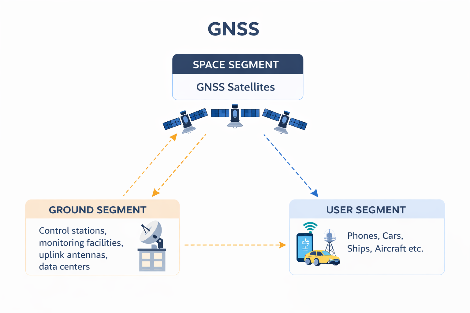
1. Space Segment: The constellation of satellites orbiting at different altitudes and orbits that continuously broadcast timing and orbital data.
2. Ground Segment: A global network of control stations, monitoring facilities, uplink antennas, and data centers that:
- Track satellite health
- Update orbital parameters
- Synchronise Satellite Onboard atomic clocks
3. User Segment
These are the receivers for signals and satellite data. They are embedded in smartphones, aircraft systems, shipping containers, telecom towers, financial infrastructure and more.
How do they work together?
Take any satellite system within GNSS. Each satellite carries highly stable atomic clocks. Atomic clocks measure time by monitoring the resonant frequency of atoms like cesium and rubidium- so, unlike our watches or wall clocks, they are the most accurate time-measures that drift significantly less. These clocks broadcast signals of the exact time the signal was transmitted.
From orbit, satellites transmit faint signals. When a receiver picks up signals from multiple satellites, it calculates how long each signal took to arrive. It compares the received time with its own internal clock. Since these radio waves travel at the speed of light, this time difference effectively computes distance. By measuring its distance from at least four satellites, a receiver uses trilateration to compute latitude, longitude, altitude and time correction with respect to Coordinated Universal Time (UTC).
To put just how crazy this is into perspective, light travels at the speed of 300,000 km/s. So an error of just 0.1 microseconds would mean a positioning error of 30 metres! That’s the difference between having a good evening vs the awkward conversation after accidentally ringing the bell at the wrong door. Or between taking the next right on a highway vs having to drive another 10 kilometers before you get to take a U-turn.
The timing capability is just as critical. Each satellite’s atomic clock provides a globally synchronized time reference accurate to billionths of a second. That timing signal is used to coordinate telecommunications networks, timestamp financial trades, synchronize power grids, and manage data networks that span continents. Much of the modern world relies on this invisible layer of precise timing to keep complex, distributed infrastructure running in sync.

GNSS encompasses multiple systems from different countries like GPS (USA), GLONASS (Russia), Galileo (EU), BeiDou (China), NavIC (India), and QZSS (Japan). In the space segment, each GNSS constellation consists of approximately 30 Medium Earth Orbit (MEO) satellites between the altitudes of 19,000km and 24,000km. Exceptions are NavIC satellites which are on a combination of Geostationary Orbit (GEO) and Inclined Geosynchronous Orbit (GSO) at around 36,000 km above earth’s surface and QZSS satellites on Quasi-Zenith orbits at altitudes between 32,000 - 40,000 km.
Modern receivers use and combine signals. Such a multi-constellation architecture improves satellite visibility, geometric diversity, accuracy and availability of data. While each system is independently operated, together they form the global framework that enables receivers to determine their precise location and time.
GNSS are integral to modern society, supporting activities like navigating ships, aiding aircraft landings, and providing precise timing information for critical infrastructures. It has become deeply integrated and relied upon by many sectors, including automotive, finance, telecommunications, maritime, aviation, and energy.
So where did GNSS come from? Who built it, and why?
Let’s rewind.
Navigation, for most of human history, was an exercise in patience. Ancient sailors used stars. Explorers relied on compasses, sextants, and chronometers. Even as late as the early 20th century, knowing exactly where you were, especially at sea or in the air, was hard.

The breakthrough came from war and geopolitics.
The year was 1957- the Cold War in its full glory. The Soviet Union launched Sputnik, the world’s first artificial satellite, triggering the Space Race with America.
But American scientists tracking Sputnik noticed something curious: they could determine the satellite’s position by observing the Doppler shift of its radio signals. They later expanded the idea: If a satellite location could be determined from the ground via the frequency shift of its radio signal, then the location of a receiver on the ground could be determined by its distance from a satellite.
That insight planted the seed for satellite-based navigation.
The Global Positioning System (USA)
The system we now casually call “GPS” was born in the United States during the Cold War.
The U.S. Department of Defense (also referred to as the Department of War) wanted a navigation system that was global, always available, independent of weather, and accurate. After multiple experimental programs through the 1960s and 70s, this effort crystallized into the Global Positioning System (GPS).
The first GPS satellite was launched in 1978. By the mid-1990s, the full constellation was operational. That single decision reshaped the global economy.
Initially, GPS was strictly military. Civilian access existed, but accuracy was deliberately degraded through a feature called Selective Availability. That changed in 2000, when the U.S. government switched it off, instantly improving civilian positioning accuracy worldwide. Because it was first and widely adopted, nearly every GNSS receiver is designed with GPS as baseline compatibility.
As GPS became indispensable, other nations faced a strategic problem. Relying on a foreign, military-controlled navigation system isn’t ideal, especially for critical infrastructure, defense, and economic resilience.
The response? Build their own systems.
The Soviet Response - GLONASS
Paralleling GPS, the Soviet Union began developing GLONASS (GLObalnaya NAvigatsionnaya Sputnikovaya Sistema- translated to English as Global Navigation Satellite System) in the 1970s as a military system. Its orbital inclination is higher than GPS, offering strong coverage over northern latitudes, aligning well with Russia’s geography. Unlike GPS, traditional GLONASS satellites used different frequency channels for each satellite.The first satellite launched in 1982, achieving full operation with 24 satellites in 1993, also supporting civilian use cases. After the Soviet Union’s dissolution led to a temporary decline, the system was modernized and restored in the 2000s. Today, it operates as a fully global system.
The EU’s Civilian Approach – Galileo
Unlike GPS or GLONASS, which were originally military-led programs, Galileo was conceived from the outset as a civilian-controlled system. Launched in the early 2000’s, Galileo introduced design choices focused on service assurance and high precision. It offers multiple signal services, including a Public Regulated Service (PRS) for authorized government use. Its advanced commercial services designed for higher-accuracy applications like search-and-rescue have reduced emergency response times globally
China’s entry - BeiDou
China's BeiDou started in 1994 after GPS reliance risks during crises like the 1991 Gulf War. It evolved in phases- from regional coverage in the early 2000s to full global capability by 2020. BeiDou is distinct for its hybrid constellation, combining MEO satellites with GEO and IGSO satellites to strengthen regional performance, particularly across Asia-Pacific. Unlike purely positioning-focused systems, certain BeiDou services also incorporate short-message communication capabilities.
India’s Sovereign Response - NavIC
The need for an independent system became particularly evident after the 1999 Kargil War, when access to GPS data over the Kargil region was denied to India. Though felt earlier, this experience further highlighted the inevitable need for an indigenous satellite system.
India's NavIC (Navigation with Indian Constellation, formerly IRNSS) was approved in 2006 for regional coverage over India and 1,500 km beyond its borders. The first of seven satellites launched in 2013, fully operational by 2016. In addition to the L5 (common GNSS band), NavIC transmits on the less-common S-band as well, which can improve resistance to interference. It supports defense, disaster management, civilian services and fleet tracking with better equatorial accuracy. This prioritizes regional reliability and sovereignty while reinforcing national technological independence.
Japan’s Urban Optimization – QZSS
Japan approached satellite navigation with a different constraint: dense urban environments. In cities like Tokyo, tall buildings obstruct low-elevation satellites, reducing signal reliability and increasing multipath errors. QZSS was engineered specifically to address this challenge. Its satellites follow highly elliptical, inclined orbits designed so that at least one satellite remains nearly overhead close to the zenith for extended periods. This high-elevation geometry improves signal availability in urban “canyons.”
What's truly unique is that governments fund and operate GNSS as public infrastructure. The open signals are provided free of charge to global users. This model enabled rapid commercial innovation, consumer device integration, and global interoperability. Unlike telecommunications networks or internet infrastructure, GNSS access does not require subscription.
This decision accelerated the development of entire industries, from ride-hailing to precision agriculture. Few infrastructure systems have had such global economic leverage at zero direct cost to users.
GNSS has evolved far beyond its origins. It operates continuously, quietly, and at planetary scale. Today’s positioning ecosystem is shaped by multiple nations building for autonomy, resilience, and precision. National strategic projects collectively turned into a globally interdependent framework. GNSS is no longer simply a navigation technology. It is infrastructure. Invisible. Continuous. Foundational.
But positioning needs to evolve.As autonomy increases, urban environments densify, and systems demand higher integrity and precision, the architecture of positioning needs to and will continue to mature.
GNSS has achieved something remarkable. And it is now time to think more and think ahead.